

Contents:
Summary of Town History
Primary Historic Areas: Hamlets
Historic Bridges
Parks/Forests/Natural Elements/Historic Landscapes
Monuments, statues & public art
Cemeteries
Bells
Historic Markers
Historic Districts
Historic Buildings/Structures/Historic Landscape
Other Collections
Summary of Town History
On July 10, 1761 the royal governor at the time, Benning Wentworth, made his 26th, 27th, and 28th grants west of Connecticut River creating the towns of Bridgewater, Hartland, and Woodstock. The town of Woodstock was granted to a group of 62 proprietors who were speculators in new lands, named primarily for political reasons, and very soon were bought out by others.
Up until this time, Woodstock had remained unsettled. Tradition tells of Timothy Knox coming into the town in 1765 and erecting a log hut near a place called Beaver Meadows, on what is now the Kedron Brook, but he had no deed to any of the land that he occupied. Titled settlers began arriving in 1768 led by Andrew Powers, John Sanderson, and Joseph Call, all of who carried deeds from Oliver Willard, and settled in the northeastern corner of the town, near present-day Taftsville and along River Road. By 1771, there were 42 persons (19 under the age of 16) living in Woodstock, in ten families.
By 1772, no New York charter had yet been issued for Woodstock. In fact, under the decree of 1767 cited above, no new grants were allowed. And yet despite this situation, on the third day of June 1772, Oliver Willard prevailed when his own petition for a grant to himself and 23 associates was recognized by the granting of the New York Charter still on display in the Woodstock History Center. The very next days, June 4 & 5, 1772, all 23 of Willard’s associates conveyed their interests in Woodstock to him. Oliver Willard had title to the entire town! Willard’s first order of business was to repay his political benefactors, resulting in grants of large tracts of land. Willard also issued several quitclaim deeds to smaller land owners whose titles did not derive from New York, while at the same time reinforcing his jurisdiction as the sole grantee of the town.
By 1791, when Vermont joined the Union as the fourteenth state, Woodstock had grown to a sizable frontier community with stores, taverns, a courthouse, and jail. The town owed its early success as a commercial center to its favorable valley location on the Ottauquechee River and to the political maneuvering which made Woodstock the shire town or county seat of Windsor County. Doctors, lawyers, craftsmen, and merchants made Woodstock their home, prospered, and built the elegant brick and clapboard homes surrounding the Green. During the early 1800s the state legislature met for a time in Woodstock, and the town's dominance over its region was firmly established.
In the 1840s Woodstock reached its greatest size, with a population of more than 3400. As one of the three largest towns in the state, it exerted a powerful economic influence over all the upper Connecticut River valley area. Sheep raising became a boom industry throughout northern New England, and Woodstock, like many other Vermont towns, had a large woolen mill in constant operation. There were also grist mills, tanneries, woodworking shops, silversmiths, jewelers, and cabinetmakers in the village, as well as many other types of tradesmen. Almost every home around the Green had a workshop, office, or store on the property. The broad unpaved village streets were crowded with pedestrians, carriages, delivery wagons, and stagecoaches.
By the end of the Civil War, Woodstock's influence as a trading center had begun to diminish. In 1875 the town was given a new economic lift by the completion of the Woodstock Railroad, a fourteen-mile spur line from the nearby rail center in White River Junction. Wealthy families from Boston and New York traveled to Woodstock for their summer holidays, and the town's reputation as a quiet, picturesque retreat began to grow. In 1892 the "new" Woodstock Inn, a rambling Shingle Style resort hotel, was built on the south side of the Green to accommodate the crowds of stylish patrons. A golf course was established at the Woodstock Country Club in 1895; bicycling and tennis were also popular summer sports at the turn of the century. Woodstock had redefined itself as a tourist destination. For many years Woodstock continued to attract visitors, although the railroad was forced to close during the Depression.
Today, Woodstock continues to enjoy a reputation as a tourist town, but it also has many people who enjoy the quiet, small town life that this town has to offer. Woodstock's appeal for the modern visitor is many-sided, based on the town's attractive location and layout, its well-preserved 19th century architecture, and its numerous modern resort facilities. Woodstock is a small, quintessential Vermont town, retaining seasonal, part-time and year-round residents.
Primary Historic Areas
The Hamlets of Woodstock
The Town of Woodstock is fortunate to have numerous historic assets, including the designation of three areas as National Register Historic Districts, so designated by the National Trust for Historic Preservation. These are in the hamlets of Taftsville, South Woodstock, and the Village of Woodstock. Additionally, there other important historic “hubs” in Woodstock, currently not designated as Historic Districts, which consist of West Woodstock and Prosper. The hamlets were clusters of community started around a major activity such as a mill. Stores opened, churches, grange halls and meeting houses were built, and people settled in these communities, surrounded by farmers working the land around these settlements.

View of West Woodstock from Rose Hill Road.
Prosper, was formerly named English’s Mills after Joel English who ran a local mill located at the junction of Austin Road and Rt. 12 on Prosper Brook (now called Barnard Brook). Mr. English employed a large mill crew, the Prosper school educated its children, and farmers along Barnard Brook did well. When the residents applied for a post office in the later part of 1890s they were asked to choose a name without the word “Mills” in it. They chose the name Prosper in honor of Mr. English’s prosperity.
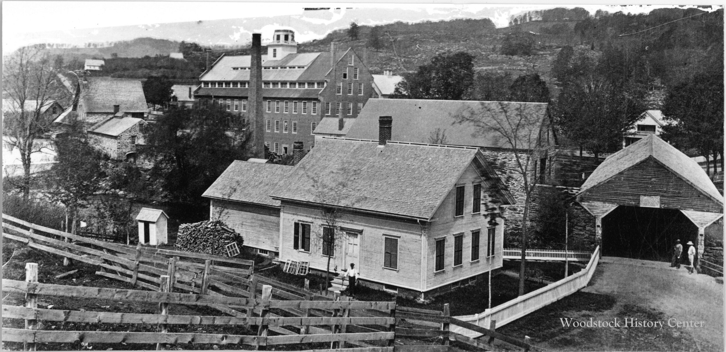
West Woodstock, had at one point had its own store, school and post office. It was anchored by Daniels Machine Company, a large manufacturing facility which sat adjacent to the site of the current Woodstock Farmer’s Market. There was a dam here on the river, and a mill pond to generate water-power for the factory. There has also been many bridges spanning the river at this location. This area was an important road intersection that connected multiple Woodstock neighborhoods and communities. A part of West Woodstock was referred to as “The Flats” before being renamed. The earliest reference to the name West Woodstock occurs in 1869. The renaming of this hamlet was quite controversial at the time and people stated that were only west of the village and remained firmly in the center of Woodstock. It was suggested that the bustling hamlet be named, Centerville, which never happened.
South Woodstock, once called the South Parish or South Village, has its main section listed as a National Register Historic District. This hamlet has always felt like a separate town with its own schools, academy, stores, tavern, hotels and manufacturing mills along the Kedron Brook. It continues to maintain its own post office today. Farming on Fletcher Hill and Long Hill, especially during the sheep boom, was very successful.
Taftsville, also listed as a National Register Historic District, was anchored by the large iron manufacturing facility on the river, operated by the Taft Family. There were also mills on Happy Valley Brook, and a brick yard there. Here were stores, a church, and in the late 1800s, a railway station. The valley straddling Happy Valley Brook also has a successful farming community. Taftsville is named for the first settler of the village, Stephen Taft, who arrived from Massachusetts around 1793, although there seems to have been agricultural settlement in the vicinity earlier. He soon built a power dam on the Ottauquechee River, and a factory on the south riverbank to make axes, scythes, and other edge tools necessary in this period of expanding agriculture. His brother Daniel Taft arrived as an apprentice in 1794, and later set up his own business. Meanwhile, Stephen Taft built a sawmill on the north riverbank. Later came a plow and stove factory, a gristmill, a shingle mill, a chair factory, a brickyard, a blacksmith shop, a tannery, and a slaughterhouse.
Village of Woodstock, listed as a National Register Historic District, was organized on the first Monday in January 1837 and provided for the election of five trustees as the governing board of the village. Originally, this section of town was called the North Village or “the Green”. It began in 1772 with the family of Joab Hoisington and grew to about 1,500 in the mid-1880s. The original limits of this portion of town were laid out in 1819 in an effort “to restrain certain animals from running at large within the villages of this State.” Over the century and a half, the village has become firmly established as the commercial, economic and political hub of the town.
Willow Vale, is situated about one mile north of the Village and its entrance was about where the Pomfret and Barnard roads meet at what has been called “Thompson’s garage.” The area extended out towards South Pomfret along the Pomfret Road and also along Rt. 12 towards Prosper. The “Vale” has always contained many beautiful meadow farms and fine residences. At one time it was noted for its fine flocks of Merino sheep and later dairy operations. Its inhabitants were described as “enterprising, hard-working people, noted for their industry and frugality.” The name of the Vale derives from the shrubbery that dominated the Barnard Brook. Over the years, the identity of Willow Vale has merged with Prosper and there are only a few locals living in this area who remember the name.
Historic Structures: Bridges
Middle Bridge (1969): Seven different styles of bridges spanned the Ottauquechee River at the Middle Bridge location, including a covered bridge, which lasted from 1850 to 1869. In 1877, an “elegant and substantial” modern iron bridge was built and patterned after the girder truss bridges developed for railroads. The iron bridge lasted for almost 100 years until it was condemned and replaced in 1969. Milton Graton was hired to build Middle Bridge in the traditional way using peg-framed construction. Graton rescued old bridges or built new ones from Georgia to Maine. Along the way he achieved a bit of celebrity, with interviews in national publications and an appearance on Charles Kuralt’s TV series On the Road. That same year saw the razing of the beloved but aging Woodstock Inn, which was replaced by the present Woodstock Inn & Resort, under the direction of Laurance Rockefeller. The old iron bridge has many defenders, and some grumbling accompanied its demolition. On May 11, 1974, the very night of the Fireman’s Ball, the five-year old Middle Bridge was set afire. There is no functional metal in the trusses of the Middle Bridge, the lattice members being held in place with some 1,400 trennels, turned from 23 white oak trees from New Hampshire.
Lincoln Bridge (formerly Williams Bridge): The original “Williams Bridge” washed away in a freshet in October 1869. It was rebuilt and was referred to as the Lincoln Bridge. This bridge washed away when the ice broke up in March 1877. It was built again in 1877 by two brothers, B.H. Pinney of Woodstock and R.W. Pinney of Bridgewater. This bridge is one of the only known examples of a wooden Pratt truss bridge in the United States. This type of bridge construction was devised by T. Willis Pratt. The bridge’s 134 foot span is in the form of an arch, with wooden uprights enclosed, and cross bracing of iron rods. Until the bridge was completely renovated in 1947 an old poster still clung to the interior, advertising P.T. Barnum & Co.’s Great Roman Hippodrome. The Lincoln Bridge was listed on the National Register of Historic Places in 1973. The bridge sustained damage during Tropical Storm Irene and more recently two separate oversized vehicles.

Taftsville Bridge
Taftsville Bridge (1836): Built in 1836 by Solomon Emmons III, a longtime Taftsville resident, this is the oldest bridge in Windsor County. All evidence indicates Solomon used no existing patented bridge truss designs. Stone piers were sunk into the riverbed and wood from local forests was used. This was cut and peeled at the rate of $1.00 per 1000 feet. The cost of the bridge was $700 and the stonework abutments and center pier cost $1,000. Originally eight, 90-foot timbers carried the bridge. The posts were chestnut and diagonal braces were spruce. The original superstructure is framed in an innovative “multiple king-post” truss pattern. Later, the original builder installed laminated arches for added strength. The bridge’s two spans across the Ottauquechee stretch 189 feet at the floor level making it the second longest covered bridge in Vermont. The only crossing in the six-mile stretch between Woodstock and Quechee, the bridge at Taft’s Mills saw constant traffic to and from the small but busy industrial hub that was early Taftsville. The cost of upkeep was a puzzle, as the bridge is at the junction of several towns and controversies arose as to assignment of costs. Finally, the Legislature ceded 15 acres of Hartland soil to Woodstock. On August 28, 2011, Tropical Storm Irene devastated the south abutment, closing the bridge for two years while extensive repairs and restoration efforts were made.
c. 1793 Settlement of Taftsville, construction of dam
1807 1st Taftsville Bridge washed out in flood and soon replaced.
1836 Solomon Emmons III builds the present covered bridge.
1851 Until this time, maintenance monies were paid jointly by Pomfret, Hartland, Woodstock, and Hartford. A legislative act in 1851 ceded 15 acres of Hartland soil to Woodstock.
1869 Bridge damaged during the “Freshet of 1869 and afterwards is raised. Capt. Edwin Emmons takes over the maintenance from his father and raises the bridge 3 feet. Edwin re-shingles the roof four times during his lifetime.
? Addition of laminated arches.
1902 Construction of electric generating station.
1909 Present dam is built.
1952-53 Major repairs to the bridge.
c. 1959 The Bridge is painted red. This is the 1st coat of paint.
1973 Listed on the National Register of Historic Places.
2011 Tropical Storm Irene significantly damages the bridge.
2012-13 Restoration of the current bridge.

West Woodstock Bridge.
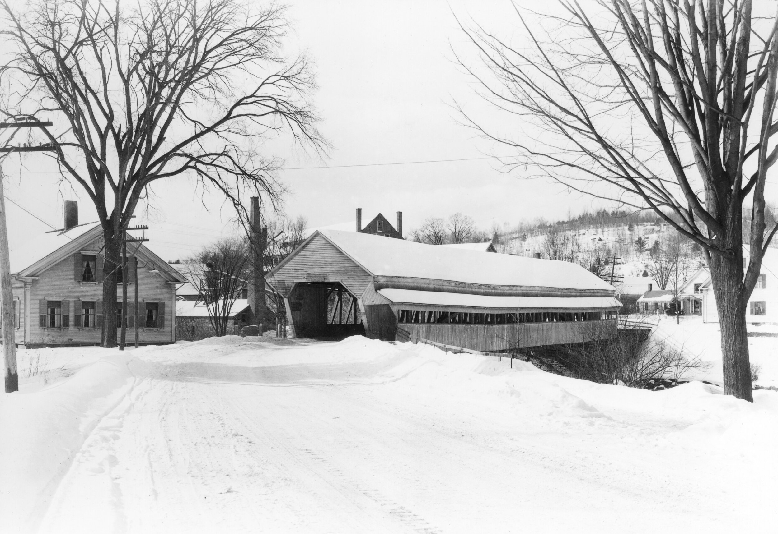
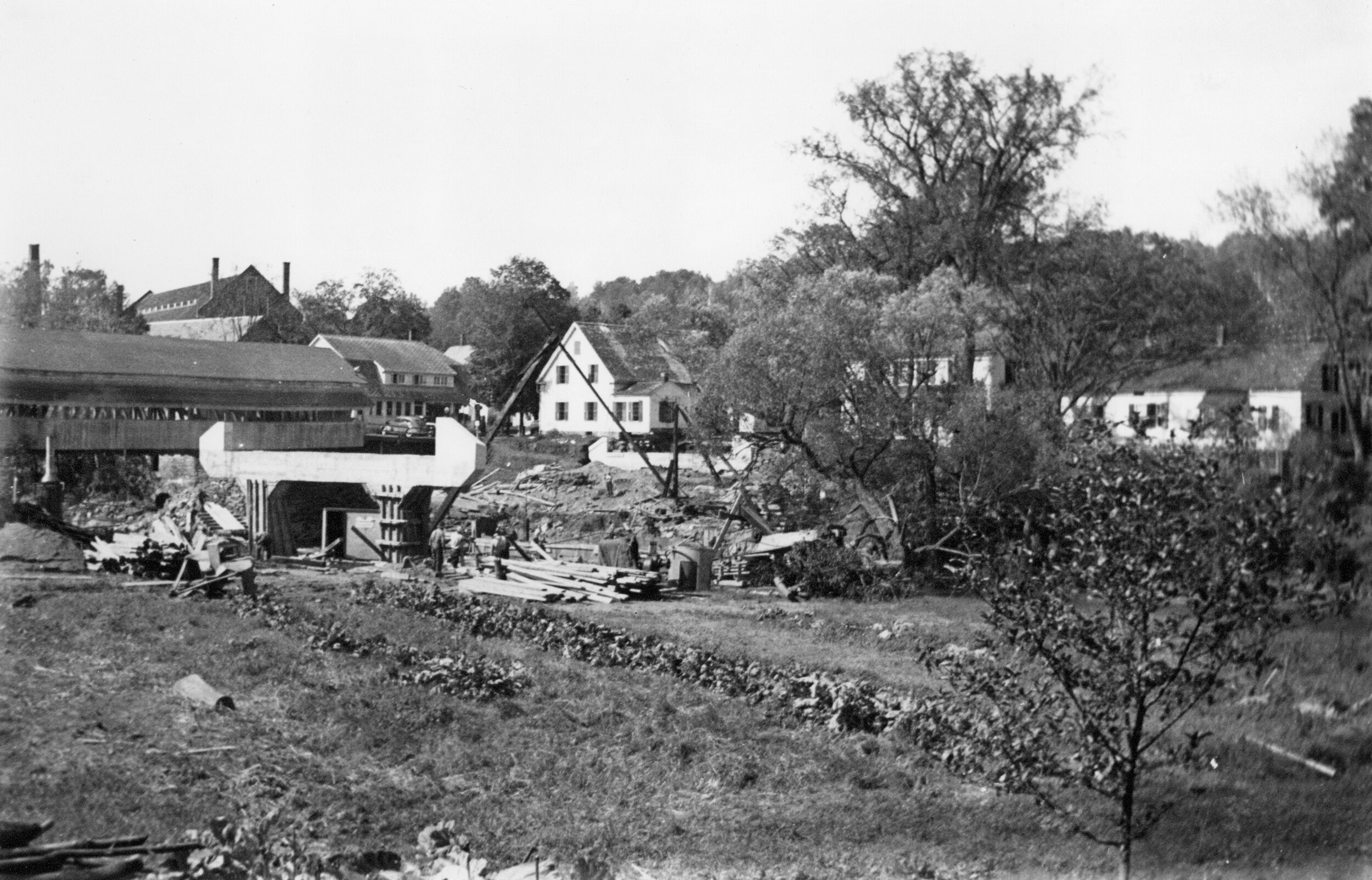
West Woodstock Bridge (1900): The bridge work began about November 14 by Groton Bridge and Manufacturing Company men under the direction of J.S. Hunter. The bridge was finished and opened for travel on December 7, 1900. The total cost for the bridge and placing it on the site was about $6,000. The bridge is 173 feet in length, 32 feet in height, and 16 feet in width, and weighs more than 50 tons. It was listed on the National Register of Historical Places on September 9, 1982. A rehabilitation of the "Mill Bridge," or the West Woodstock Bridge was completed in June 2002. "The renovated bridge will allow small trucks, school buses and fire trucks weighing up to 40,000 pounds to use this bridge. The project is a unique way to maintain the historical integrity of the structure and add carrying capacity to the bridge. The solution that was designed involved building an arch to surround the outside steel members. This arch supports a new floor system and increases the load carrying capacity of the bridge from 3 tons to 20 tons. The total cost of the construction was approximately 1.5 million, and the town paid approximately $75,000. This work could not have been accomplished without the federal and state grants that we received for this project." Annual Report 2001-2002, Town of Woodstock
Read more about this bridge on our blog, The Acorn.
Elm Street Bridge: There had been at least seven structures across the Ottauquechee River at the current site of the Elm Street Bridge. The first was built in 1797 and the last one seen today was erected in 1870. That's an average of one bridge every ten years! Shortly after the first bridge was built, the site was acquired by the Royalton and Woodstock Turnpike Company. From 1801 to 1841, this company was forced to rebuild the crossing six times- a fact which may have ultimately led to the company's demise.
There were apparently several reasons why the turnpike's proprietors had such difficulty in keeping a bridge at Elm Street. The most obvious is the general susceptibility of wooden bridges to fire, flood and rot. While there is no record of a fire on any of the Elm Street bridges, at least three were carried away by high water and other became unsafe due to decay. The 1818 bridge erected by William and Barna Raymond rotted to the point where it became a public hazard. In an attempt to force the turnpike company into action, two local men tried unsuccessfully to pry it into the river. It survived until 1827 when it was finally replaced by a covered bridge. While the advent of the covered bridge alleviated some of the problems of rapid decay, it did not eliminate the hazard of flood. Covered wooden bridges floated as well as uncovered ones and the Ottauquechee carried away the Elm Street bridge in 1857 and 1869. The 1857 flood destroyed the southern abutment indicating that the width of the stream bed was too narrow to accommodate the river's flood stages at this point. Following a similar recurrence in 1869 both abutments were moved back a few feet and the southern one raised to provide a channel 14 feet wider.
The reconstruction of the abutments was part of a new, more scientific approach which characterized the 1869 work. Woodstock had become caught up in the sweeping changes which began in the middle of the past century and which, for lack of better term, we call the Industrial Revolution. Within 30 days of the washout, a pile driver had been procured in Boston to rebuild the southern abutment. By mid-November, about 130 piles, 'mainly of spruce and twelve to fifteen feet long' had been driven into the sandy soil of the southern bank. Twelve massive, rough-hewn stones were laid on the piles to form the foundation of the abutment. The largest of these was the east cornerstone measuring 12 feet in length and weighing 5 tons. Work proceeded on the abutments until December 11 when winter weather suspended further operations until April 1870.
The superstructure of the new bridge was also characteristic of the new spirit of industrial enterprise which seemed to flower after the Civil War. When a town meeting was held on October 21, 1869 to levy taxes for reconstruction, Charles P. Marsh moved that the new structure be made of iron. The motion carried and on November 4, the Vermont Standard reported that a contract had been signed with Blodget and Curry, proprietors of the National Bridge and Iron Works of Boston. The contract called for an iron bridge, 110 feet long at a cost of $31 per linear foot or a total of $3,410, FOB, Boston. It was estimated that the cost of erection, freight, and the wood for decking would bring the cost of the superstructure to about $4,000.
Woodstock's first iron bridge is an early example of the spread of iron bridge technology from railroads to highways. With few exceptions, the techniques of iron bridge design and construction had been pioneered by railway engineers during the 1840s and 1850s. Iron founders, such as Blodget and Curry, viewed these developments as potential markets for expansion. Bridge engineers saw them as new fields for the application of their specialized talents. Many of the new bridge companies were a combination of the two roles with the engineer providing designs based on mathematical calculations while the iron founder carried out their fabrication. At the National Bridge and Iron Company, Charles H. Parker was responsible for structural design, while A.W. Parker, presumably a relative, was Superintendent of Works. William A. Blodgett and Cadwallader Curry were 'proprietors' and probably exercised financial control. Whatever the division of responsibility at the National Bridge and Iron Company, the physical evidence shows that the two functions were well integrated. The Elm Street Bridge and other designs patented by C.H. Parker display a concern for structural integrity coupled with economy of materials and ease of fabrication. All these factors contributed to the company's success and their bridges became numerous throughout New England."
Elm Street Bridge, 1870, rehabilitated 1980, contributing structure. The bridge, constructed in 1870 by the National Bridge & Iron Company of Boston and rehabilitated in1980, carries Elm Street (VT Route 12) across the Ottauquechee River. It is a single-span, wrought- and cast-iron, pin-connected Parker pony truss bridge with stone abutments and wood sidewalks between the arched trusses and an ornamental iron railing. Load-bearing steel stringers were added below the truss in 1980. The bridge is a significant early example of iron highway bridge construction.
Kedron Brook Bridge: The Kedron Brook Bridge is a historic stone arch bridge arch bridge, carrying Densmore Hill Road across Kedron Brook in southern Woodstock, Vermont. Built about 1810, it is one of the state's older stone bridges, built from locally gathered stone. It was listed on the National Register of Historic Places in 1992. The Kedron Brook Bridge is located in a rural residential area of southern Woodstock, just east of the junction of Densmore Hill Road and Vermont Route 106. The bridge is a small single-span structure, 14 feet (4.3 m) wide and 22 feet (6.7 m) long, rising to about 9 feet (2.7 m) above Kedron Brook. The edges of the bridge are lined with a low concrete curb, on which a simple wooden railing has been mounted. (At the time of its National Register listing, it still had apparently original metal stanchions with yokes; these have since been removed.) The bridge's arch is fashioned out of irregularly shaped stone, which is predominantly granite, but includes other stone types commonly found in the vicinity. The exterior surfaces of the stone have been worked to some degree, and the gaps have been pointed with sandy mortar. This bridge was built about 1810 and is of a type that were once quite common in the state and were typically found in clusters where skilled stonemasons lived. The critical elements of the arch would have been built by such a mason, while the rubble fill and other elements of the work would have been done by lesser skilled labor. This bridge, while significantly older, is stylistically similar to the early 20th-century bridges of James Otis Follett, found in the Townshend area of Windham County.
Marble Bridge (also known as Upper Bridge): This bridge was originally a wooden covered bridge and linked Woodstock with the west as the highway crossing for the mails, stagecoaches, and other transportation. In 1938, modern needs dictated that another bridge be built and the once famous landmark, which had served the town for nearly a century, became a memory. The new structure was finished in 1939 is sometimes referred to as the “Rec Center Bridge”. The wooden bridge was torn down on June 22, 1944.
Central Street Bridge: 1935 bridge replaced in 2018. A Historic Resource Documentation Package of Woodstock Village Bridge 51 was prepared for the Vermont Agency of Transportation by Mary Jo Llewellyn, Architectural Historian. This document is available at our John Cotton Dana Research Library. You can make a research appointment here.
Parks/Forests/Natural Elements/Historic Landscapes
Environmental Background: Woodstock Village is situated on the Ottauquechee River, a tributary of the Connecticut River. This riverine network provided Native Americans access from the Connecticut River from small streams feeding the Ottauquechee. The village lies in the Vermont Piedmont physiographic region. The Vermont Piedmont is bounded on the west by the eastern foothills of the Green Mountains and on the east by the Passumpsic and Connecticut Rivers. It is characterized by plateau-like uplands, steep-sided valleys, small hills, and deeply incised streams. The growing season of the Vermont Piedmont is about 130 days, “poorly suited for horticulture”. While most of the Piedmont is covered with stony soils, riverine areas are characterized by fertile sand, silt, and clay, with glacial till in the valleys. The predominant terrace soil of the county, lying mostly above the flood plain, is Merrimac fine sandy loam.
Parks:
Faulkner Park: The Faulkner Park and the Faulkner Trail were carefully created by Mrs. Marianne Faulkner, over 75 years ago, as a place of quiet respite and healthy exercise, in memory of her husband, Edward Daniels Faulkner. Mrs. Faulkner based the trail design on the cardiac rehabilitation trails of the famous spas in Baden-Baden, Germany, where people from all over the world came to take "The Cure." The Faulkner Trail leads to the South Peak of Mount Tom, from which you can take in an impressive view of Woodstock and the surrounding countryside. The Faulkner Trust stewards Faulkner Park. Completed in 1937. The project appears to have been designed by Pollock & Halborson of Pittsfield, Mass., with A.J. Pollock advising, and Ed Lord on the site supervising crews. A.B. Lane Construction of Barre, a skilled masonry firm completed the construction.
Resurrection Park: This property on River Street, formally owned and occupied by Elizabeth Dunbar and Mrs. William Moore, opposite the Riverstreet cemetery, was deeded to the town of Woodstock in 1907. The Woodstock Improvement Society purchased clear title to this property to create an open space or park, adorned with shrubs and flowers. This park no longer exists. Time and erosion have contributed to its demise. It is unknown whether there is any property left that can be determined to be owned by the Town of Woodstock.
East End Park: The East End Action Group has been able to regroup following a significant loss of land at the proposed riverfront park site during the flood. Before Irene, Sustainable Woodstock’s East End Action Group built community support, raised funds, and developed plans for this park. While Irene changed the project’s scope, the concept remains, and scaled back plans are re-focused on restoring the health of the river. The project has been endorsed by eight Woodstock civic organizations, and the Village Trustees have officially designated the land as a park. In Fall 2012, the East End action group hosted two “Jungle Tour” site visits, a community information meeting, and a “Green Up Day” to plant the riverbank. Another community work/information event was held in Fall, 2013. By October 2014, enough progress had been made to hold a “Farewell to the Jungle” celebration. All these events elicited broad public support and involvement. The proposed project will measurably increase water quality in the Ottauquechee River; rehabilitate a badly deteriorated parcel of prime riverside land; restore an area seriously damaged by Irene and protect downstream properties; offer post-Irene educational opportunities; and create a valuable recreational facility for town residents and visitors alike. The East End project has been obtaining significant funding for cleaning up the long-neglected “jungle,” addressing invasive plant issues and putting in an ecologically sensible “riparian buffer” of trees, shrubs and native plantings that will help maintain water quality and protect the stream bank during high water. As one of the grant proposals put it, “The project restores floodplain and riparian areas using native vegetation to correct and prevent erosion by filtering runoff, reducing volume, preventing erosion and enhancing soil stability with diverse root structure, and slowing the velocity of the river during flooding events.” Other portions of this underutilized site will be developed for public parking and reserved for commercial development. The East End project will remove an eyesore at one of the town’s major gateways, provide public recreation, and support the growth of local business enterprise.
Teagle’s Landing: A small park or "small oasis, resurrected from the litter of man and flood." It was named Man and Nature Park in 1983. Later, the landing was named in honor of Frank H. Teagle, Jr. who was a caring and dedicated Woodstock resident, and a steward of resources. The park had an extensive renovation in 2021.

The Green. Prior to 1873 when they installed a metal fence around the common.
Vail Field: In 1895, Henry H. Vail gave to the Village of Woodstock his six-acre Park meadow lying on south of the Inn along the Kedron Brook. The Trustees voted to accept deeds to the property known as the Sayward dam and Park meadow; the dam, which was to be removed, was acquired “by private subscription” of $2,400 and a Village appropriation of $500. Park meadow, valued at $1,500, named Vail Field, was designated as a “free public playground and field for athletic and outdoor sports.” Circuses and “travelling exhibitions” were proscribed by deed; a baseball diamond and a grandstand seating three hundred were installed in 1897. The Woodstock Improvement Society enhanced the park at one point, adding playground equipment and hiring a playground supervisor.
Tribou Park: Purchased by the town in 1881, from the estate of Jonas Tribou. Before Jonas died, he enclosed the grounds and planted a grove of trees that proved a significant force in encouraging the town to purchase lots in order for preservation and public use. In October 1882, the idea of creating a park in this location is discussed. The name is determined in November of 1882.
The Green (The Park): In its early years, the Green was far from scenic. In Henry Swan Dana’s History of Woodstock, Dana describes the first common as “rough and uneven as when first taken from the native forest. Not even the cellar of Jason Richardson’s tavern, which had been removed to the westerly side of the Common, was filled up, except as time did the work. Travelers passed over the grounds much as they pleased, though teams generally kept along the highway. Not a tree was to be seen anywhere, and scarcely a fence in front of any of the houses.” The land for Woodstock’s original common (shown to the right as a yellow overlay) was granted by Israel Richardson to the people of Windsor County in 1788. Originally some half dozen buildings, including the courthouse and jail, were built around the common. In 1793 the common was enlarged to essentially its present size and dimensions. In 1810 Lombardy poplar trees were planted on the common in an attempt to improve its appearance; however, the poplars met an unceremonious end one night when they were pulled up and thrown into the river, perhaps because they were thought to harbor worms. That did not end efforts toward beautifying the common. Sometime between 1820 and 1830, plows and harrows were used to level the parts of the Green that were uneven and rough. Grass was sown and some small trees planted. These trees did not last long, and in 1830, efforts were made to replant trees again — this time help was enlisted from a group of boys whose job was to water the trees on a regular basis. By the 1870s, the Green had an abundance of trees, as shown in the above photograph. Woodstock’s Green, like the central commons in other New England towns, was the site for social and political events. In early times, it was also the site of the pillory, where punishments were carried out. Later, in 1846, the first Windsor County Agricultural Society fair was held on the Green. For this fair, stock was shown in and around the park and horses in the street. This fair was later expanded and moved to the Windsor Country Fair Grounds (which are now part of the Billings Farm and Museum Property). In more recent years, the Green has been a spot where the community has held events ranging from dinners to craft fairs, plays, and musical concerts. See The History of the Green: Woodstock’s Central Park. Elm Tree Press publication, 2017.
Billings Park on Mt. Tom & Mt. Peg: The Billings Park Commission manages Mount Peg Park and the Billings Park, two town parks that are connected by the Walk Woodstock trail system. Ten acres of land on Mount Peg that was once used as a golf course was purchased to become a public park in 1908 by Miss Elizabeth Billings. In 2002, the Billings Park Commission and the Woodstock community raised funds to add 44 acres to Mount Peg Park and permanently connect its trails and vistas to the village center and the Woodstock Trails Partnership network. Billings Park (including the South Peak of Mount Tom) is 155 acres and was created in 1953 by John French, Mary French Rockefeller and Elizabeth French Hitchcock in memory of their mother, Mary Billings. Billings Park on Mt. Tom, a gift to the Town, is 130 acres. Billings Park on Mt. Peg is 62 acres.
Woodstock History Center backlawn/park: A matching gift by Laurance Rockefeller in 1963 began an effort to establish a park-like area behind the museum. This “park” is privately owned by the Woodstock History Center but they allow the public to use it.
Municipal and State Forests
The Billings Lot is a 22/23-acre woodlot near the Vondell Reservoir managed for periodic timber harvests. There are no signs and it is not easily identified. Size, access, and steep slopes limit recreation.
The Long Hill Block near South Woodstock, consisting of 100 acres, was originally a source of wood for the poor farm. The forest lay dormant for many years and then was rediscovered in the late 80s. It consists of mostly good hardwoods on mildly sloping land.
The state of Vermont owns 797 acres of forest reserve in South Woodstock off Long Hill Road and Curtis Hollow Roads. that is part of the Coolidge State Forest.
Monuments, statues & public art

New Soldier’s Monument in Tribou Park. Dedication ceremony, 1909.
New Soldier’s Monument in Tribou Park, statue and canon: The G.A.R. raised the money for another memorial, topped by a granite soldier, executed by W.F. Howland, who had put up the large Mormon shaft in Royalton. The New Soldier’s Monument, erected in Tribou Park in April 1909, ‘In memory of the boys in Woodstock and vicinity who served in the Army and Navy of the nation in the War of the Rebellion of ’61 to ’65,’ was dedicated on Memorial Day.” The canon, known as a Parrott rifle, was installed in 1899. It was referred to in The Vermont Standard as “the big government gun” which weighed over three tons. A sum of $25 was raised by subscription to defray the expense of getting it to Woodstock. The Randall Post, G.A.R. bore the cost of mounting it., was installed on a low granite platform near the center of the park.It was given to the George Randall Post of the Grand Army of the Republic by the U.S. Government (Springfield Reporter, 7/7/1899).
D.A.R. monument: Information pending.
WWII monument: Information pending.
George Randall Post School Monument: In June 1907 the George Randall Post accepted Thomas S. Jackson’s design for a twenty-five-foot granite monument, a Doric column surmounted by a bronze eagle. Disagreement over its location polarized the town. The veterans wanted it on the lawn between The Norman Williams Library and the Court House, at the eastern end of The Green, or in Tribou Park, but The Green was vetoed at a Special Village Meeting, and the Williams family objected to the library site. Despite considerable pressure to select Tribou Park, the Village voted in October to place the memorial in front of the school on South Street, where it was duly raised in December. Inscribed in Latin on its Barre granite base were the lines from Horace: ‘Glorius and sweet it is to die for the native land.’
Post Office Mural: “Cycle of Development of Woodstock” – oil on canvas by Bernadine Custer (1940). New Deal Art in Woodstock, Vermont. This Post Office mural was funded by the Section of Fine Arts under the Treasury Department and not the WPA. The painter, Bernadine Custer had been living in Londonderry, Vermont, when she was awarded two U.S. Post office projects: one in Summerville, South Carolina and the other in Woodstock for which she would be paid, $23.00 a week. After conducting her own research and utilizing borrowed portraits, Custer designed the mural which would be viewed from left to right. The characters on the extreme left represent unnamed local pioneers and then a man representing all farmers followed by likenesses of Hosea Ballou, John C. Dana, and Jacob Collamer. The mural was completed in 1939.
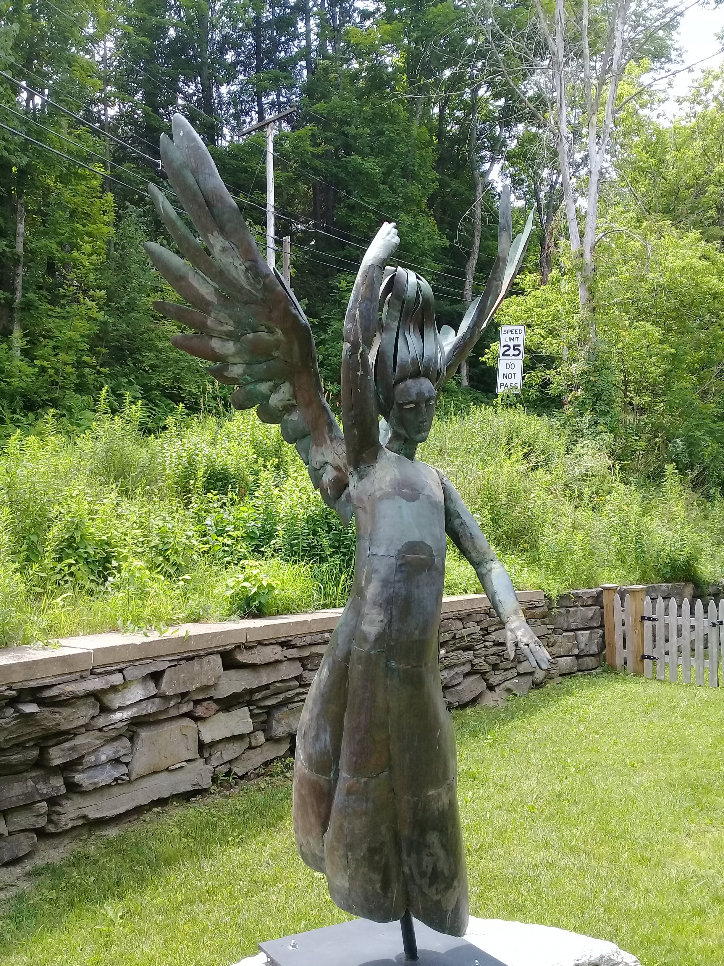
Angel of Bethesda
Angel of Bethesda (St. James Episcopal Church statue): Created by Mary Eldredge. This sculpture was originally located on Elm Street on the property of Byron and Ivy Thomas and was unveiled at the Thomas’ house on September 23, 1966. The piece was created by Eldredge for her Master of Fine Arts thesis at Rosary College. The piece was donated by Ivy Thomas and her daughter Murray Ngioma to the St. James Episcopal Church. Restored by Jeffery Sass in 2017.
Cemeteries
A major historic resource within the Town of Woodstock is its cemeteries. Some of these may have been a single headstone, but more likely they were a family grave site on the small farms scattered throughout the community. By the late 1800’s, there were more formal cemeteries that were under the auspices of churches or associations or the Town of Woodstock itself. Addition cataloguing of cemeteries should be conducted the production of maps as well of cemetery locations and their history.
The town is directly responsible for eight cemeteries: Highland, Hendy, Smith, Cushing, Randall, Jacquith, Kendall-Ransom and Shaw Cemetery. The Commissioners are considering taking over the maintenance of four additional small cemeteries (2014). Separate private associations are responsible for ____ other cemeteries. The remainder are private burial grounds and approximately _____ have been abandoned.
Curtis Hollow Cemetery
Cushing Cemetery (corner of Cloudland Farm Road and Old River Road)
Doubleday Cemetery (private, South Woodstock)
Farnworth-Cottell
Fullerton Cemetery (South Woodstock)
Green Cemetery (private, South Woodstock)
Hall Burial Ground (private)
Hendee Cemetery (Rose Hill): Handy Cemetery. This cemetery was given by Jesse Williams in 1787.
Highland Cemetery (Rose Hill)
Jacquith Cemetery (South Woodstock)
Joslyn Cemetery
Long Hill Cemetery
Methodist Burying Ground (South Woodstock)
Morgan Cemetery
North Cemetery (Taftsville River Road)
Old Burying Ground
Prosper Cemetery (Prosper Road)
Randall Cemetery (South Woodstock)
Kendall-Ransom Cemetery (South Woodstock)
Riverside Cemetery (Route 4 west and Rose Hill)
River Street Cemetery (Village)
Shaw Cemetery
Smith Cemetery (South Woodstock)
Taftsville Cemetery (Route 4 east)
Walker Cemetery
Washburn Family Burial Grounds
Wyman Lane Cemetery
Search more here: https://www.findagrave.com/
Bells

Christian Church (now Masonic Temple) bell
Christian Church bell: In 1826, the Christian Church (which became the Masonic Temple in 1949) was built on Pleasant Street. Two years later, in 1828, a church member named Eliphalet Dunham purchased an 872-pound bell from Revere of Boston. The clock mechanism was attached to the bell and for some years it would toll the half hour as well as the numbers of each hour.
St. James Episcopal Church bell: The St. James Episcopal Church purchased its bell through members, Stearns and Blake, a year after their new stone building was erected in 1826. There is conflicted information about how much it weighs. One source states that the bell weighs 693 pounds and another 619 pounds. Supposedly, the bell was first rung from the belfry at the 1827 Christmas service. It is inscribed "Revere Boston".
Universalist/Unitarian Church bell: The Unitarian Universalist Church was built in 1835, and its bell weighs in at 1,021 pounds.
Congregational Church bell: The Congregational Church on Elm Street was designed and built by Nathaniel Smith in 1807. Its bell, the oldest in Woodstock, may be found displayed near the entrance to the Congregational Church. The bell was purchased by a member, Willis Hall, from Revere and Sons of Boston in 1818. It weighs 711 pounds and cost at the time .45 a pound. After it cracked, the bell was replaced with one from Holland. The cost of that bell was $9.13 a pound. A similar bell, which is Vermont's earliest, hangs in the Norwich Congregational Church and was tuned to "C." It is interesting to note that when Norwich found it necessary to reframe its bell, an oak timber from an old Woodstock covered bridge was provided for that purpose. A new bell was installed at the Congregational Church in 1975-1976.
Woodstock Inn bell: This bell, which used to reside in the garden behind the Woodstock Inn, was purchased by philanthropist and resident Laurance Rockefeller in the late 1960s. The idea to purchase this bell occurred in 1967. It was cast in 1823 by the Boston Foundry for a church in Newburyport, Massachusetts. It weighs 1,463 pounds and has the key of G.
Woodstock Country Club bell: This bell was reinstalled at the Woodstock Country Club in 2018. The bell was owned by Laurance Rockefeller.
Green Mountain Perkins Academy bell: An etching of the corner of The Green and Mountain Avenue shows the court house bell tower which is located on the left and the school bell tower on the right. The bell that once graced the belfry on the schoolhouse was taken down and moved to the Orion Grange Hall (it was a schoolhouse before that) in South Woodstock. It was later moved to the Green Mountain Perkins Academy. It was cast by William Blake & Company. Boston. The Green Mountain Perkins Academy have recently restored the bell and belfry. The photo below is the bell before it was restored.
Historic Markers
Across from 28 Mountain Avenue. Marianne Gaillard Faulkner. 2011
Church Hill Road, south of Shurtleff Lane. Hiram Powers. 1999
Rt. 12, east of Gully Rd. Woodstock, Vermont- Site of the First Ski Tow in the United States. 1964.
Rt. 4 in Taftsville, at Covered Bridge Road. Taftsville Covered Bridge. 2013
Rt. 4 on the Village Green. Woodstock. 2010
Historic Districts
Historic Districts by Local Governments: Another mechanism to provide protection for historic resources is the creation of a locally controlled historic district for areas with a distinctive historic and/or architectural character. Woodstock has adopted three such districts- Village of Woodstock, Taftsville, South Woodstock.
The Woodstock Village Historic District was listed on the National Register of Historic Places in 1973. It includes the village center and additional properties along the Ottauquechee River. The district covers an area of 275 acres (111 ha) encompassing 95 buildings, sites, and structures that contribute to the historical significance of the area. The center of the district is an elliptical village green located at the junction of U.S. Route 4 and Vermont Route 106. Around the green and along the main road following the river are several residential, commercial, and public buildings showcasing architectural development from the late 18th to late 19th centuries. One of these buildings is The Norman Williams Public Library, built by Norman's son, Dr. Edward H. Williams, on the site where their home had stood previously. The district also includes the Billings Farm and Museum, and the George Perkins Marsh Boyhood Home, the architectural centerpiece of Marsh-Billings-Rockefeller National Historical Park.
The Taftsville Historic District encompasses a historic 19th-century industrial village that is mostly in Woodstock, Vermont. Flanking the Ottauquechee River and extending up Happy Valley Road, the area developed around a metal tool factory established by members of the Taft family in 1793. Important elements from its early history include the Taftsville Store, built by the Taft family in 1840, and the Taftsville Covered Bridge, built in 1836. The district was listed on the National Register of Historic Places in 2001.
Description and history: The village of Taftsville is centered around the junction of United States Route 4 and Happy Valley Road in far eastern Woodstock. It extends along secondary roads (mainly Happy Valley Road and Sugar Hill Road), and includes properties neighboring Hartland and Hartford, both just east of Woodstock. Most of its buildings are residential in character and were built in the 19th century. They are typically wood frame structures either 1-1/2 or 2-1/2 stories in height, although there are a few brick houses. The village's industrial past is primarily recalled by the dam across the Ottauquechee River, which now powers a hydroelectric plan on the river's southern bank, adjacent to the covered bridge. The Taftsville Store, built in 1840, is a prominent landmark on US 4, a major transport artery in the area. A former school building, now serving as a Mennonite chapel, stands on Happy Valley Road; it was built in 1911, and has Colonial Revival features.
Settlement of the village began in 1793, when Stephen Taft, a native of Uxbridge, Massachusetts arrived. He and two of his brothers dammed the river, established a sawmill on the north bank, and a metalworking shop in the south bank, producing scythes, axes, and other tools in the latter. The business was a success and flourished into the late 19th century despite its original main building's destruction by fire in 1811. The surviving covered bridge was built in 1836 to handle increasing traffic (across an earlier footbridge), and the store was built in 1840. It is unclear if the Tafts built the store as a place to sell their wares, or as a service to their growing number of employees. The village was originally more roughly divided between Woodstock and Hartland, but a town boundary adjustment in 1851 placed most of the village into Woodstock.
The South Woodstock Village Historic District was listed on the National Register of Historic Places in 1983. The historic district consists of 44 contributing and 11 non-contributing properties over an area of 360 acres (150 ha), including a significant concentration of brick buildings. The district includes examples of Greek Revival and Federal architecture from before the American Civil War. Notable buildings include an 1825 school that became a Grange Hall, the South Chapel (1839), and the Perkins Academy (1848).
Scenic Ridgeline District: Woodstock’s Scenic Ridgeline District was established in 1992 in response to the adverse visual impacts of development on the scenic qualities of the Town’s prominent ridges and hillsides, which contribute significantly to the Town’s aesthetic identity. Conditional use review and approval are now required for any proposed development within 500 feet of the Town’s primary ridges, as identified on the Scenic Ridgeline Map located in the Planning and Zoning Office. The Scenic Viewshed Map was completed in 2005 using computer analysis to identify all viewsheds visible from the town’s principal road corridors.
Other National Register Individual Sites
Lake – Kendall Farm (Owen Moon Farm) 1816, 1937
Marsh Billings House 1805, 1885
Lincoln Covered Bridge 1877
Kedron Brook Bridge 1810
Woodstock Warren Through-Truss Bridge 1925
West Woodstock Bridge 1900
Rev. George Daman House (Wyman Farm) 1782
State Register of Historic Places: The Vermont State Register of Historic Places is the state’s official list of historic properties significant to the history of the Green Mountain state. Established in 1979 and administered by the Division for Historic Preservation, the Vermont State Register is an essential tool for the evaluation and protect Vermont’s historic and archaeological resources. The same criteria are used to evaluate resources for inclusion in the State Register as are used for the National Register.
Other Historic Buildings/Structures/Historic Landscape/Artifacts
Prosper Community House: Information Pending.
Town Crier: Information Pending.
Welcome Booth on the Green: Legend has it that this structure, which was Frank Teagle’s chicken coop, was moved in the middle of night by Frank (and others) to the Green.
Green Mountain Perkins Academy: Built in 1848 and currently the Green Mountain Perkins Academy & Historical Association
Green Mountain Horse Association: Nation’s oldest continuously operating horse association
Upwey Barn
Schools: Pelton, West Woodstock School, School on Green, River Street School, Taftsville, Prosper, Cox, Lincoln, Branch, Walker, Curtis, South Woodstock, Fletcher, Woodstock Elementary, Woodstock High School
Prosper Ski Cabin: In 1992 the Keeper of the National Register of Historic Places at the National Park Service formally determined that the Prosper ski cabin was eligible for inclusion in the National Register of Historic Places. The Prosper Ski Cabin was a rare surviving building of the late 1930s era and historically significant for association with Vermont’s ski industry. The cabin was in remarkably good condition given the lack of any maintenance, but something would need to be done to keep it from further deteriorating.
Appalachian Trail Conservancy: The Appalachian Trail is a 2,184 mile long public footpath that traverses the scenic, wooded, pastoral, wild, and culturally resonant lands of the Appalachian Mountains. Conceived in 1921, built by private citizens, and completed in 1937, today the trail is managed by the National Park Service, U.S. Forest Service, Appalachian Trail Conservancy, numerous state agencies and thousands of volunteers. It's corridor passes just north of Woodstock Village.
Marsh-Billings-Rockefeller National Historical Park: In 1992, the Billings Mansion, outbuildings and approximately 550 acres of the land was given to the United States government to create the Park.
Marsh-Billings-Rockefeller National Historical Park is the only National Park to tell the story of conservation history and the evolving nature of land stewardship in America. The Park operates in partnership with the Woodstock Foundation, Inc., and the Billings Farm & Museum. The Park interprets the historic home of the Marsh, Billings, and Rockefeller families, their conservation work and stewardship of the forest landscape, and the emergence of an American conservation ethic. The 550-acre woodlands continue to be managed for protection of natural resources, education, recreation, sustainable forestry, history character, and scenic beauty.
The Mansion
Gardens & grounds
Outbuildings
Billings carriage roads
The Pogue
Billings Farm & Museum: Stretching along the Ottauquechee Valley, the Billings Farm & Museum serves as a gateway to Vermont's rural heritage. In 1871, Frederick Billings began importing cows from the Isle of Jersey and developed his farm into a model of agriculture improvement. His farm prospered, and today, is still one of the finest Jersey farms in America. The Billings Farm & Museum was established in 1983 by Laurance S. and Mary F. Rockefeller as a working dairy, and a museum dedicated to telling the story of Vermont's rural heritage. The Billings Farm & Museum is open daily May 1 through October 31, 10AM-5PM, weekends in November and December and winter holidays, 10AM to 4PM. 1890 farmhouse and creamery.
Vermont Land Trust Properties
King Farm: The King Farm, with its main house, barns, sheds, garages, outbuildings, hayfields, pastures and woodlands, is an excellent example of an early self-sustaining hill farm which has, through adaptation to evolving farming practices and the efforts of successive owners in the past two centuries, been able to stay in continuous diversified agricultural use since 1793. Comprised of eleven contributing buildings, consisting of a farmhouse/hired farmer’s quarters (1), main barn (2), sheep barn (3), granary/corn house (4), milk house (5), ice house (6), ash house (7), workshop (8), horse shed (9), guest house - also called “the Club” (10), and summer house - also called “The Tent”(11), and located on 157 acres of hilly terrain one mile west of Woodstock, VT, in the Ottauquechee River Valley, this farm retains its integrity of design, setting, location, materials, workmanship, feeling and association, and meets the registration requirements for the property type “Farmstead”as included in the Multiple Property Documentation Form "Agricultural Resources of Vermont." The King Farm's 154 acres of farm and forest land boarders the National Park to the West. In keeping with the wishes of Francisca King, the farm is used for the purposes of agriculture, forestry, conservation, and education, and has been stewarded by the Vermont Land Trust since 1986.
Gilbert’s Hill: Located on the north side of Barnard Road (Vermont Route 12), approximately two miles from the village of Woodstock, Gilbert’s Hill is a good example of a small farmstead in east central Vermont that evolved over the course of the 19th century and into the 20th century. The property is known both as Gilbert’s Hill and the Appel Farm. The property is significant for its contributions to the agricultural history of Woodstock and the surrounding regions. It is also significant as the location of the first ski tow built in the United States, in 1934, powered by a Model-T Ford engine. The tow ran up the steep slope on the north side of the property. Areas of significance for the district are recreation, agriculture and architecture. Gilbert’s Hill qualifies for National Register listing under Criterion A, as it is associated with events that have made a significant contribution to the broad patterns of our history. Along with the well-preserved farmhouse and other ancillary agricultural structures, the property features well delineated fields and tree lines. The farmstead and surrounding lands portray the evolution of Vermont agriculture over the past one hundred twenty-five years and relate directly to the historic contexts of "Dairying, 1850 - 1941" and "Diversified and Specialty Agriculture, 1760 -1940." Gilbert’s Hill is also significant for its contributions to the broad patterns of recreational history related to Vermont's ski industry, an important part of the state’s larger tourism industry context. Gilbert’s Hill retains its integrity of location, setting, design, materials, workmanship, feeling and association. The property meets National Register Criterion C as an intact historic farmstead. It embodies the distinctive characteristics of a type, period, or method of construction and contributes to Vermont's agricultural and settlement history. The property relates to statewide themes of Historic Architecture and Patterns of Town Development; Agriculture; Contact, Exploration, Conflict and Early Settlement; and Tourism. The period of significance is 1842 -1964, which spans the years between the approximate construction date of the first structure on the property and the approximate date that the ski area closed.
Stone highway markers

A stone turnpike marker is located at 1 The Green. It is dated 1802 and shows the southern terminus of the Royalton and Woodstock Turnpike which opened for traffic in the spring of 1802. The stone was originally located farther out in the road and was relocated closer to the building to protect it.
Stone chambers
Chamber 2- South Woodstock
Other historic artifacts
Time capsule: A capsule of Vermont Bicentennial memorabilia is buried at the foot of the Vermont Historical marker on the Green. It is to be dug up in 2091.
Fire Truck: 1923 Maxim. Located at the Woodstock Fire-EMS Department.
Other Collections
Portrait of Franklin Swift Billings, Jr.: Husband, Father, Grandfather & Speaker of the Vermont House of Representatives; Vermont Supreme Court Judge; Chief Justice, Vermont Supreme Court; Chief Judge, United States District Court for the District of Vermont. Collection of the Superior Courtroom, Windsor County Courthouse, Woodstock, Vermont. The portrait was bestowed upon the Windsor County Courthouse on November 15, 2020.
Horse Block: Located in front of 20 Pleasant Street.